Semuliki National park covers an area of 220km2; it lies in the remote Bundibugyo district, beyond the Rwenzori Mountain on the floor of the Semuliki section of the Albertine Rift Valley.  This largely forested park represents the easternmost limit of the great Ituri Forest of the Congo Basin and contains numerous species associated with central rather than eastern Africa. Thatch huts are shaded by West African oil palms; the Semuliki River (which forms the international boundary) is a miniature version of the Congo River, while the local population includes a Batwa (Pygmy) community that originated from the Ituri. Semuliki is one of Africa’s most bio diverse forests and is particularly noted for its varied bird population. Today the Semuliki valley is a greenhouse for vegetation growth, with temperatures rising to a humid 30°C doused by an annual 1250mm of rain, mostly between March-May and September-December.
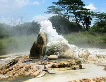
Hot springs bubble up from the depths beneath Sempaya to reveal the powerful subterranean forces that have been shaping the rift valley during the last 14 million years. The low lying park lies on the rift’s sinking floor, most of it just 670m above sea level. Large areas may flood during the wet seasons; brief reminders of the time when the entire valley lay at the bottom of a lake for 7 million years.
Activities:
Scenic Viewing: Two hot springs are situated in a tract of hot mineral encrusted swamp land, where visitors see a two meter jet of hot water (130oc) and a pool (12m diameter) of oozing boiling water (106oc) . One can boil food especially eggs in the natural boiler within 10 minutes and eat it.
Nature walks: Nature walks always starts from Sempaya Gate and takes about 2 hours ending to the Hot Springs of 10m diameter through the rainforest with Palm Trees and partly muddy ground. On the walk, tourists have a chance to see primates like Mangabeys and Blue Monkeys, mammals such as forest buffaloes, elephants, Sitatunga, leopards, pygmy hippopotamus, as well as birds such as Hornbills, Honey guides and Palm nut Vultures. There are also 305 species of trees recorded, of which 125 species are restricted to this park alone.
Community visits: Near the park, there are “Batwa”, a local pygmy Ituri ethnic group of people. Their livelihood basically depends on fruit gathering and hunting in the forest. Today there is a mixture and cultural exchange with other ethnic groups started. A community visit to the pygmy village near Sempaya Gate will enable you witness their lifestyles, traditions, dances, as well as an opportunity to buy souvenirs.
Bird watching: Birding is another tourism activity that can be carried out during the safari. The varying vegetation types offer birders the chance to see different birds which include forest birds, wetland birds, grassland birds as well as water birds.
Getting to the park:
There are two major roads from Kampala to Fort Portal: Kampala-Fort Portal via Mubende is about 180 Km. (about 4-5 hrs drive) while Kampala -Fort Portal via Masaka, Mbarara, and Kasese is about465 Km (7-8 hrs). In both routes 2-wheel drive vehicles can be useful. While the Kampala-Fort Portal via Mubende is much shorter, the Kampala-Fort Portal via Masaka, Mbarara and Kasese gives you opportunity to Visit Lake Mburo National Park, Kyambura Wildlife Reserve, Rwenzori Mountains National Park and Queen Elizabeth National Park.